Procedural
Longitudinal
Longitudinal
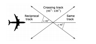
Longitudinal separation shall only be applied between aircraft on same or reciprocal tracks.
Longitudinal time separation must be established by using pilot estimates and ensuring that the time between two aircraft is equal or greater than the longitudinal time separation minimum.
Phraseology
"ABC, Cross ALPHA at time 1051 or later"
"DEF, Hold at BRAVO to leave BRAVO at time 2215 or later"
Time
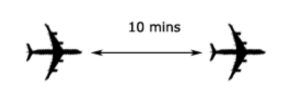
Same Track
Aircraft that are on the same track, including situations where one aircraft is climbing or descending through the level of another, are to be separated by 10 minutes
Reciprocal Track
Aircraft flying on reciprocal tracks may only be separated vertically. Such separation must exist at least 10 minutes prior to the estimated time of passing
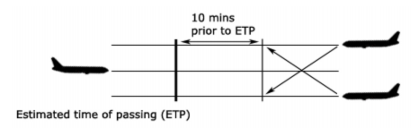
After the estimated time of passing, aircraft may not climb or descend through the level of the opposite direction aircraft until 10 minutes after the estimated time of passing. It is possible to reduce this requirement if definite passing has been achieved, and this will be explained later in this section.
Distance
Distance Reports
Distance standards cannot be applied using the Bearing-Range Line Tool, since the position displayed on the scope is just an estimation of where the aircraft is.
Instead, it must be done using actual reports from the aircraft, using GNSS or DME.
The lead aircraft must be tracking directly to/from the aid. Always ask the lead aircraft for their distance report prior to the following aircraft.
Distance checks must be conducted as per the following table:
| If | Conduct Distance checks at intervals of not less than |
|---|---|
| No speed control has been applied | 15 mins |
| Speed control has been applied to limit closing to less than or equal to 35kts or Mach 0.06 | 15 mins |
| There is closing of more than 35kts or Mach 0.06 | The standard is not valid |
| Speed control has been applied to have opening or stable distance | 30 mins |
Same track
20nm
| Conditions | |
|---|---|
 |
|
Reciprocal track
5nm Definite Passing
| Conditions | |
|---|---|
| Distance Reports (using GNSS or DME) indicate that the aircraft have passed and the distance is opening | |
 |
|
Sight and Pass
| Conditions | |
|---|---|
| a) Both aircraft report sighting and passing the other by day (and in Oceanic airspace by night); b) Both aircraft are above A100; and c) You ensure there is no possibility of incorrect identification by either aircraft. |
|
 |
|
Opposite sides of visual fix
| Conditions | |
|---|---|
| a) Both aircraft report passing the same visual fix; and b) The visual fix must be a prominent topographical feature within 10,000 FT of the levels of each aircraft |
|
 |
|
Lateral
Lateral
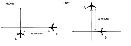
Time-based crossing track
Aircraft that are on crossing tracks, including situations where one aircraft is climbing or descending through the level of another, are to be separated by 15 minutes at the point of intersection
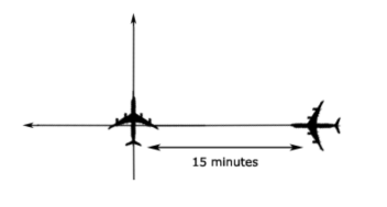
Where a difference 15 minutes does not exist at the crossing point, vertical separation shall be applied from the time at which the second aircraft is 15 minutes from the crossing point until the first aircraft is 15 minutes past the crossing point.
Conflict Area
Conflict Area
The quickest and easiest way to assess lateral conflict scenarios is with the Conflict Area tool. Unfortunately, whilst its quick and easy to use, it's fairly complex and long to understand the rules and concepts.
The first thing to note, is that there are many different unusual remarks and equipment codes that pilots file on VATSIM, primarily because not everyone knows what they mean. A little bit of background knowledge is required to understand these concepts.
NAVCAPs
All aircraft have a NAVCAP, associated with a Circular Error of Position. This determines which number to select when using the Conflict Area Tool:
| NAVCAP Code | Meaning | Circular Error of Position (CEP) |
|---|---|---|
| A | All | 7nm |
| 2 | RNP2 | 7nm |
| 4 | RNP4 | 14nm |
| 5 | RNAV5 | 14nm |
| T | RNAV10 | 14nm |
| Z | None | 30nm |
The minimum number you must select when using the tool, is equal to: Aircraft 1 CEP + Aircraft 2 CEP + 1nm
Example
Aircraft 1 NAVCAP: 4
Aircraft 2 NAVCAP: Z
14+30+1=45
Example
Aircraft 1 NAVCAP: 2
Aircraft 2 NAVCAP: A
7+7+1=15
Tip
The best scenario is to have 2 aircraft that are RNP2 approved. "Feed the beast" in order to get what you want, that is to say "QFA12, confirm you are RNP2 approved?", and they'll probably say yes. Enter NAV/RNP2 in the flight plan remarks, and you can use a 7nm CEP.
Working with Conflict Area
Once you've established the Conflict area, you now know the area in which the aircraft are in lateral conflict. You can now either separate from the conflict area using a Time Standard, or a Distance Standard:
Time standard (5 minutes prior to time shown at entry, or 5 minutes after time shown at exit); or
Distance standard (Use BRL to measure a distance to/from a waypoint that is outside of the conflict area, and use it to implement a vertical standard after exiting, or prior to entering the lateral conflict area)
Time Standard (5 in, 5 out)
Using the time standard, aircraft are considered to have entered the conflict area 5 minutes prior to the estimate shown, and to have left the conflict area 5 minutes after the estimate shown.
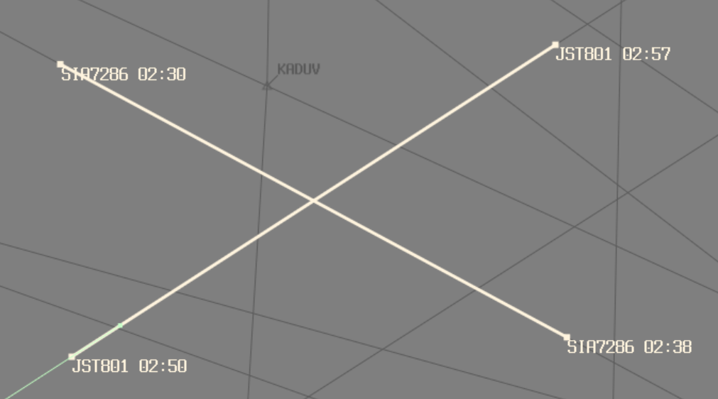
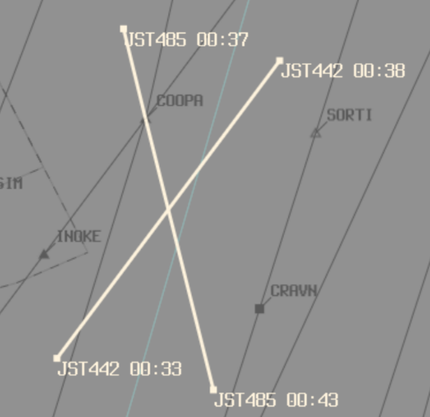
Example
JST801 estimate for entering conflict area: 0250
JST801 enters lateral conflict 0250-5: 0245
JST801 estimate for leaving conflict area: 0257
JST801 leaves lateral conflict 0257+5: 0302
JST801 is considered to be in the conflict area from time 0245 until time 0302
SIA7286 estimate for entering conflict area: 0230
SIA7286 enters lateral conflict 0230-5: 0225
SIA7286 estimate for leaving conflict area: 0238
SIA7286 leaves lateral conflict 0238+5: 0243
SIA7286 is considered to be in the conflict area from time 0225 until time 0243
SIA7286 leaves lateral conflict prior to the time that JST801 enters lateral conflict. Therefore, the 2 aircraft are not in lateral conflict
When aircraft are in lateral conflict, a vertical standard must be applied for that period.
Phraseology
"Climb to reach (vertically separated level) by (prior to entering lateral conflict)"
"Expect requested level at (time aircraft leaves lateral conflict)"
Distance Standard
Use BRL to measure a distance to/from a waypoint that is outside of the conflict area, and use it to implement a vertical standard after exiting, or prior to entering the lateral conflict area
Phraseology
"Climb to reach (vertically separated level) by (GNSS distance outside entry of conflict area)"
"Report (GNSS distance outside exit of conflict area) for requested level"
Lat Sep Table
Lat Sep Table
Lateral Separation works off the basis off establishing a Lateral Separation Point (Lat Sep point). That is, when given an angle that 2 tracks intersect at, a distance at which lateral separation is considered to exist procedurally. These figures are detailed in the table below:
| Tracks intersecting at | Lat Sep point |
|---|---|
| 0°-15° | No lateral separation |
| 16°-44° | 11nm |
| 44°-135° | 8nm |
| 136°-180° | No lateral separation |
In a more visual form, ABC can be considered to be laterally separated from aircraft in the green areas, and not laterally separated from aircraft in the red areas. This only applies to intersecting angles at the crossing point, and both aircraft tracking directly to/from the crossing point.
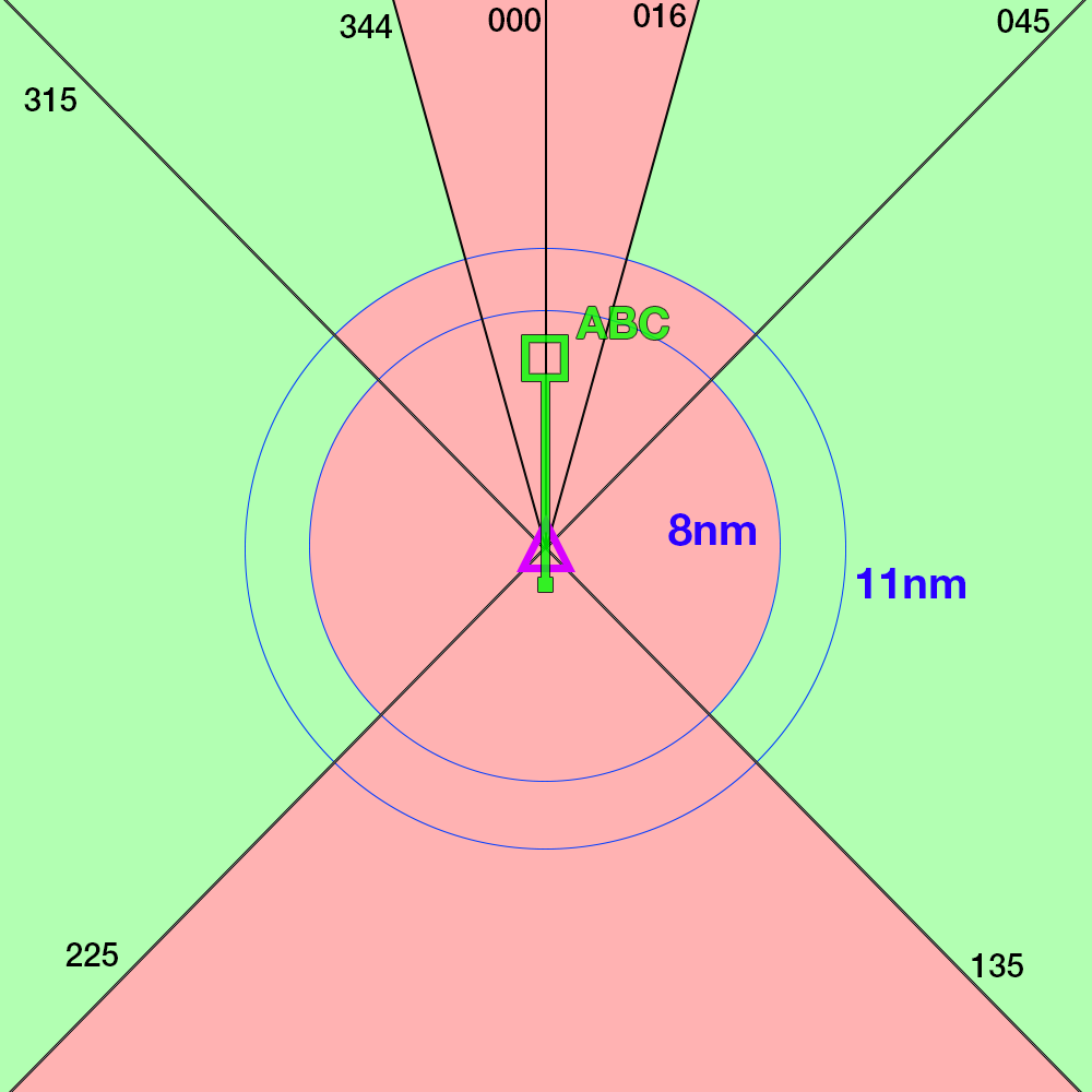
This can be used to plan restrictions as required when surveillance coverage cannot be assured.
Vertical
Vertical
1000ft
- Between any aircraft at or below
F290 - Between 2 RVSM-approved aircraft at or below
F410
2000ft
- Between any aircraft that is experiencing Severe Turbulence at any level
- Between all aircraft above
F410 - Between
F290andF410inclusive;- When at least 1 aircraft is not RVSM-approved
- Between military formation aircraft, regardless of RVSM status
3000ft
- When at least one aircraft is supersonic